What is GIS?
Geographic Information Systems (GIS) are software-based computer systems designed to pull multiple sources of information and display them together in a single map. This is extremely helpful in local government, as planning remains critical as our City continues to grow. GIS is also used for the management of utility assets and maintenance, emergency readiness and preparation, site selection analysis, and much, much more.
We're Here to Help You!
As part of Creek Compass, our GIS Department exists to provide residents, developers, and employees with up-to-date information about our community. This page will continue to be updated with new information and applications as it becomes available. If you ever have feedback, questions, or information requests, don't hesitate to contact us!
GC One-Source
This map us under development, and will be your one stop shop for all information related to an address in Goose Creek. Type in an address, and see the parcel info, school district, Council Member, and more!
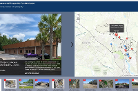
Commercial Properties For Sale/Lease
Created with vision from Goose Creek's Economic Development Department, this map consolidates information about Commercial Properties that are available inside the City Limits.
Planning/Zoning
This map is currently in development, and will provide relevant information concerning parcels, zoning, FEMA flood zones, etc.
Current Projects
This map is currently in development, and will provide information about all current projects happening around the City.